Kingdoms and Monuments of Afre-Kh

Great Mosque of Djenné (Mali)
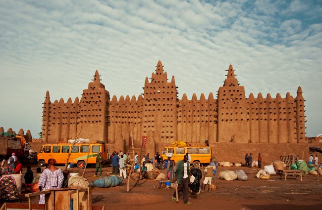
The Great Mosque of Djenné is a large mud brick or adobe building that is considered by many architects to be one of the greatest achievements of the Sudano-Sahelian architectural style.
The mosque is located in the city of Djenné, Mali, on the flood plain of the Bani River. The first mosque on the site was built around the 13th century, but the current structure dates from 1907. The actual date of construction of the first mosque in Djenné is unknown, but dates between 1200 and the late 1330s. The earliest document mentioning the mosque is al-Saadi’s Tarikh al-Sudan which gives the early history, presumably from the oral tradition as it existed in the mid-seventeenth century. The tarikh states that Sultan Kunburu became a Muslim and had his palace pulled down and the site turned into a mosque. He built another palace for himself near the mosque on the east side. His immediate successor built the towers of the mosque while the following Sultan built the surrounding wall. The Mosque is built of earth and has two massive towers. As well as being the centre of the community of Djenné, it is one of the most famous landmarks in Africa. Along with the “Old Towns of Djenné,” it was designated a World Heritage Site by UNESCO in 1988.
We also recommend: Natural Landmarks of Africa
The ancestral wall at Ouagadougou – ancient seat of the Mossi people (Burkina Faso)

In Burkina Faso, over 60 ethnic groups make up the entire population. Representing more than 40 per cent of the population, the Mossi ethnic group is the largest of Burkina Faso’s 6.2 million people. Like most of Africa, Mossi’s history is orally reconstructed, hence there is no formal documentation of their history. Despite this setback, historians estimate that the Mossi came into existence about the 11th century.
It is said that the Mossi trace their ancestry to Ghana from where they migrated to settle in Burkina Faso from northern Ghana around the turn of the 11th century. They displaced the original inhabitants known as the Nyon-nyonse. Their language, Moore, belongs to the Gur branch and is akin to that spoken by the Mamprusi and Dagomba of northern Ghana, from whom the Mossi ruling class trace their origin. The Mossi society is divided into royalty, nobles, commoners and, formerly, slaves. Each village is governed by a chief who, in turn, is subordinate to a divisional chief. The Emperor (Mogho Naaba) rules the entire population and protects the kingdom with his executive power.
The nobles (Nakomse) are second to the Emperor. They are royals from the Emperor’s family. All dignitaries are from the Emperor’s family. The Nobles (Nakomse) are often assigned territories in the kingdom as governors. They rule in the name of the Emperor (Mogho Naaba). In the past, the Emperor needed the support of the Nyon-nyonse to fully exercise his power. The Nyon-nyonse are the people original inhabitants of the land before the Mossi.
In the Mossi family, the husband and wives sleep in separate huts, the sons must leave the house as soon as they are circumcised. The wives have absolutely no status until they give birth, and when they do, their children are raised by the older wives.
The Mossi lost some of its power during the colonial period as did most of Africa. During French occupation, the Mossi were heavily exploited for labour, transported, essentially as slaves, into the rice plantations of what is now Cote d’Ivoire. Even after the abolition of the slave trade, there was political unrest, inter-regional tension in the society and a lot of strain on the community. It was in 1960 that the country of Burkina Faso gained its independence from the French. Since that time, the Mossi have been a dominant force in Burkina’s politics, and their influence runs throughout the country.
The Mossi today are spread out in a lot of French-speaking countries of West Africa and over 4 million people speak the Mossi language (Moore), the Mossi is a very influential political and social power in Burkina Faso. Although Burkina Faso has changed drastically in modern times, the Mossi people have managed to hold on to their beliefs, values and culture, unlike many African ethnic groups.
The Great Ruins of Zimbabwe (Zimbabwe)

The Great Ruins of Zimbabwe refer to the remnants of an old city that was once the capital of the Kingdom of Zimbabwe, which existed from approximately 1100 to 1400 during the country’s Late Iron Age. Zimbabwe is the modern name issued to the most prominent pre-colonial civilization in southern Africa. The name is derived from one of two possible terms: the Shona (dzimba dza mabwe or “great stone houses”) or iKalanga (Nzi we mabwe or “Homestead of Stone”).
LOCATION
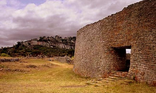
The Ruins lie in southeastern Zimbabwe, about 19 miles (30 km) southeast of Masvingo (formerly Fort Victoria). The central area of ruins extends about 200 acres (80 hectares), making Great Zimbabwe the largest of more than 150 major stone ruins scattered across the countries of Zimbabwe and Mozambique. The monument, which first began to be constructed in the 11th century and which continued to be built until the 14th century, spanned an area of 722 hectares (1,784 acres) and at its peak could have housed up to 18,000 people. Great Zimbabwe acted as a royal palace for the Zimbabwean monarch and would have been used as the seat of their political power. One of its most prominent features were its walls, some of which were over five metres high and which were constructed without mortar. The site is generally divided into three main areas: the Hill Complex, the Great Enclosure, and the Valley Ruins. The first two are characterized by mortarless stone construction, but they also include ruined daga (earthen and mud-brick) structures that may once have rivalled the stone buildings in grandeur. The Valley Ruins, located between the Hill Complex and the Great Enclosure, include a large number of mounds that are remnants of daga buildings.
ACROPOLIS
The Hill Complex, which was formerly called the Acropolis, is believed to have been the spiritual and religious centre of the city. It sits on a steep-sided hill that rises 262 feet (80 metres) above the ground, and its ruins extend some 328 feet (100 metres) by 148 feet (45 metres). It is the oldest part of the site; stratigraphic evidence shows that the first stones were laid there about the year 900. The builders incorporated natural granite boulders and rectangular blocks to form walls up to 20 feet (6 metres) thick and 36 feet (11 metres) high. Within the walls are the remains of daga houses. South of the Hill Complex lies the Great Enclosure, the largest single ancient structure in sub-Saharan Africa. Its outer wall is some 820 feet (250 metres) in circumference, with a maximum height of 36 feet (11 metres). An inner wall runs along part of the outer wall forming a narrow parallel passage, 180 feet (55 metres) long, which leads to the Conical Tower. The purpose of the tower, 33 feet (10 metres) high and 16 feet (5 metres) in diameter, is unknown, but it may have been a symbolic grain bin or a phallus symbol.
‘BUILT BY THE GREEKS’
The ruins were first encountered by Europeans in the late 19th century with the investigation of the site starting in 1871. European explorers who visited the site in the late 1800s believed it to be the legendary city of Ophir, the site of King Solomon’s mines. The monument caused great controversy in the archaeological world, with political pressure being put upon archaeologists by the government of Rhodesia to deny its construction by black people. Because of its stonework and further evidence of an advanced culture, the site was attributed to ancient civilizations such as the Phoenician, Greek, or Egyptian. In 1905, the English archaeologist David Randall-MacIver concluded that the ruins were medieval and of exclusively African origin; his findings were confirmed by the English archaeologist Gertrude Caton-Thompson in 1929.
WORLD HERITAGE
Great Zimbabwe has since been adopted as a national monument by the Zimbabwean government, with the modern state being named after it. The word “Great” distinguishes the site from the many hundreds of small ruins, known as Zimbabwes, spread across the Zimbabwe Highveld. There are 200 such sites in southern Africa, such as Bumbusi in Zimbabwe and Manyikeni in Mozambique, with monumental, mortarless walls and Great Zimbabwe is the largest. Today, the Great Ruins are preserved by UNESCO as a World Heritage Site.
Church of Saint George, Lalibela (Ethiopia)

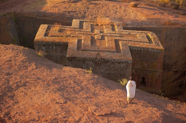
The Church of Saint George (also known as Bete Giyorgis) has been referred to as the “eighth wonder of the world”. It is the most well-known of the eleven monolithic Churches located in Ethiopia. Located in Lalibela, a city in the Amhara Region, the church was built in the 12th century, and carved out of stone. Cross-shaped, its dimensions are 25 meters by 25 meters by 30 meters and there is a small baptismal pool outside the church, which stands in an artificial trench. According to Ethiopian cultural history, the church was built after King Gebre Mesqel Lalibela of the Zagwe dynasty had a vision in which he was instructed by God to construct the church. The church was named after Saint George, the Saint who reportedly delivered God’s message to the King in the vision.
Bete Giyorgis is the most stunning of all the eleven churches, situated apart from the others to the west. Like the other churches, the Church of Saint George is part of the UNESCO World Heritage Site and is still a pilgrimage site for members of the Ethiopian Orthodox Tewahedo Church.
The Ancient Ruins of Qart-hadasht AKA Carthage (Tunisia)

One of the world’s most famous ancient ruins is the city of Qart hadasht (dubbed Carthage by Europeans who found it difficult to pronounce the original name), Tunisia in North Africa. The city came to prominence in 814 BC when Phoenician Princess Elyssa (known by locals as Dido – the wandering one) who was an exiled princess of the ancient Phoenician city of Tyre.
The original founders of Qart-hadasht were local merchants and farmers, not refugees but the Phoenician settlers found in the city a thriving trade in gold from Senegal and tin from the Atlantic coast to Europe. As Qart-hadasht grew, it caught the eyes of imperialists from Europe. Soon the city was caught in an unending spiral of wars between the Greeks and the Carthaginians. Carthage’s location as a route with inlets into the northern and southern Mediterranean gave it an advantage over neighboring cities, as ships pass between Sicily and the northern coast of Africa. This boosted Carthage’s economy giving it great power and wealth.
Carthage was one of the largest influences in ancient Africa. Its walls were large and impenetrable, 23 miles (37 km) in length, longer than the walls of comparable cities. Originally ruled by kings, in the sixth century, Rome imposed annually elected supreme magistrates, the suffetes (“judges”) to administer the colony. This form of government became the forerunner to Roman consuls. The city had a huge burial ground, religious area, marketplaces, council house, towers and a theatre and was divided into four equally sized residential areas with the same layout. Roughly in the middle of the city stood a high citadel called the Byrsa (the walled citadel above the harbour in ancient Carthage).
At the height of its glory, the influence of Carthage stretched from Gades in Iberia to Carthago Nova in South-west Europe, across the Balearic Islands, Sardinia, Corsica and Sicily into the entire coast of North Africa. This power was viewed as a threat by Rome, leading to the 3 Punic wars fought between Rome and Carthage between 264 B.C and 146 B.C that brought down Carthage. The first war lasted 23 years, the second 15 years, and the third and final war ended after 96 years when Rome razed Carthage to the ground and sold the population into slavery.
Perhaps Carthage’s most famous citizen is Hannibal, the great military tactician and strategist in European history, sworn enemy of Rome and one of the greatest generals of antiquity, thus named along with Alexander the Great, Julius Caesar, Scipio Africanus, and Pyrrhus of Epirus.
In February 1985, Ugo Vetere, the mayor of Rome, and Chedly Klibi, the mayor of Carthage, signed a symbolic treaty “officially” ending the conflict between their cities, which had been supposedly extended by the lack of a peace treaty for more than 2,100 years.
Carthage is a popular tourist location now integrated into a wealthy area of suburban Tunis.

THE MEROE PYRAMIDS (KINGDOM OF KUSH, SUDAN)
The ancient Nubian Kingdom of Kush flourished from around 2600 B.C. to 300 A.D. and held power over a vast area covering the Nile valley (modern Egypt) and extended as far as Khartoum (modern Sudan).
The Kushite kingdom at various times had its capital at Kerma (2600–1520 BC), Napata (1000–300 BC) and Meroë. The latter became very important as the Kingdom’s centre from around 300 B.C. to 300 A.D. Kush’s wealth was due to a strong iron industry and international trade involving India and China. Kerma was Nubia’s first centralized state with its indigenous forms of architecture and burial customs. The Kushite kingdom competed with Egypt and during the late period of Ancient Egyptian history, the rulers of Napata conquered and unified Egypt herself, ruling as the pharaohs of the twenty-fifth Dynasty. The Napatan domination of Egypt ended with the Assyrian conquest in 656 BC. Metalworking was conducted in bloomeries and blast furnaces in Meroe, earning it (in modern times) the name: “the Birmingham of Africa” because of the production and trade of iron to the rest of the world at a time when iron was one of the most important metals worldwide. Although Meroitic metalworkers were among the best in the world, the Kingdom of Kush also exported cotton textiles and gold. It is believed that the Egyptian word for gold nub, was sourced from the name of Nubia.
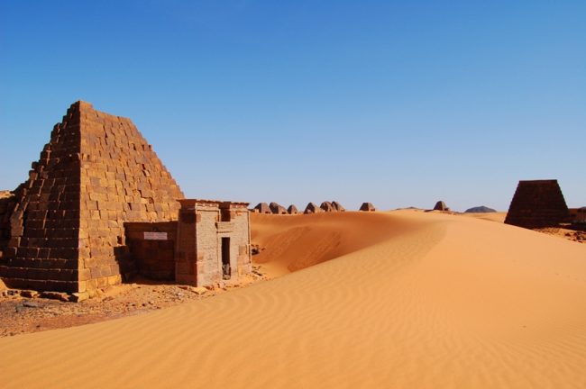
Meroe was also famous for its pyramids and tombs built to house the bodies of their kings and nobles. Described by British writer Basil Davidson as one of the largest archaeological sites in the world, the Meroe Pyramids are located in the North-East of Sudan near the banks of the Nile in the area commonly known as Nubia. There are a total of 223 pyramids in the area, double the number of pyramids in Egypt. The underground graves of the Nubian pyramids were richly decorated and also housed the remains of high-ranking priests.
The physical proportions of Nubian pyramids differ markedly from the Egyptian ones. The Meroe pyramids were constructed from large blocks of sandstone and were angled more steeply than the Egyptian pyramids, being built of stepped courses of horizontally positioned stone blocks ranging from approximately six to thirty metres in height. They rise from fairly small foundation footprints that rarely exceed eight metres in width, resulting in tall, narrow structures inclined at approximately seventy degrees. Most also have temple structures at their base, bearing unique Kushite characteristics. In comparison, Egyptian pyramids of similar height generally had foundation footprints that were at least five times larger and were inclined at angles of between forty and fifty degrees.
Excavations of the Pyramids started in the mid 19th Century. A notorious Italian explorer, Giuseppe Ferlini (1800-1870), smashed the tops off 40 pyramids in a quest to find treasure. He did find a cache of gold, which was sold. Some of the treasures remain at the museums in Munich and Berlin along with samples of Meroitic writing and reliefs depicting historical events. Through the years, the pyramids have been plundered of all their wealth and left to the elements. But many of the pyramids still stand and their architectural elegance draws tourists annually. Some of the pyramids have been reconstructed.
Visitors require a permit issued in Khartoum from the Antiquities Service. The Pyramids are situated relatively close to the town of Shendi which is on the railway line that follows the Nile. There is a village close to the ruins which may offer some basic accommodation and a long day trip can be arranged from Khartoum. Tourists are encouraged to bring along food and drink. More @ Meroe WHS
